

Lun - Ven 8:30/12:30
14:00/18:00
Sab 8:30/12:30
14:00/18:00
Sab 8:30/12:30
Tel: +39.347.123.0579
info@northair.it
info@northair.it

Kit, GPS 175, w/ GA 35, STC Product Registration 2" GPS Navigator, install rack, backplate, conn kit, config module, International datacard and product information kit
p/n. 010-01822-60
Il Kit include:
Gps Garmin 175
antenna GA 35
International Datacard
Modalità LPV
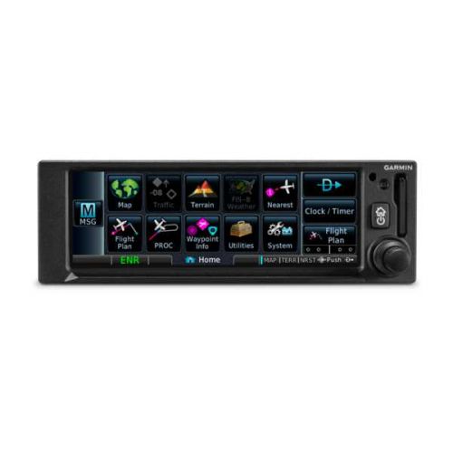
Il Gps 175 di Garmin è un navigatore GPS Touchscreen, all-in-one, per aeromobili e velivoli sperimentali/amatori.
La navigazione GPS WAAS con modalità LPV permette di espandere notevolmente le capacità operative.
E' possibile connettere il Gps 175 con altri display Garmin selezionati o optare per l'integrazione diretta con l'indicatore di deviazione di rotta (CDI) che permette un'installazione economica.
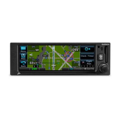
Il Gps 175 visualizza l'intero piano di volo, comprese partenze, arrivi, approcci strumentali, modelli di partecipazione e altro su una mappa in movimento. E' possibile trasferire in modalità wireless piani di volo e streaming di tempo, traffico, posizione GPS ed altro tramite la tetcnologia Connext® e l'app Garmin Pilot.
Il Gps 175 dispone di display touchscreen luminoso, ad alta risoluzione e immettendo le informazioni di volo è un gioco da ragazzi accedere ad ogni funzione. Il Gps ha mantenuta la stessa altezza di 2 ", come nelle precedenti apparecchiature, per ridurre al minimo i costi di installazione.
Touch perfetto e Navigazione Intuitiva
Nel momento in cui si accende il GPS 175 vi è una familiare homepage Garmin sul display da 4,8 ", che da accesso alle funzioni più importanti in pochi passi. Navigare in pagine dedicate per la mappa in movimento, il terreno, gli aeroporti più vicini, il piano di volo, le procedure, le informazioni sui waypoint, le utility e altro ancora è molto semplice. E' possibile inserire i dati del waypoint con la tastiera su schermo e con il pulsante Home è possibile tornare alla pagina principale in qualsiasi momento.
Per una maggiore stabilità del Gps durante il volo, una mensola sul lato inferiore del display serve a stabilizzare la mano. Per chi preferisce i controlli tradizionali, le manopole concentriche forniscono un altro modo per controllare molte delle funzioni del navigatore GPS 175.
Aggiunta di ADS-B e visualizzazione di meteo e traffico
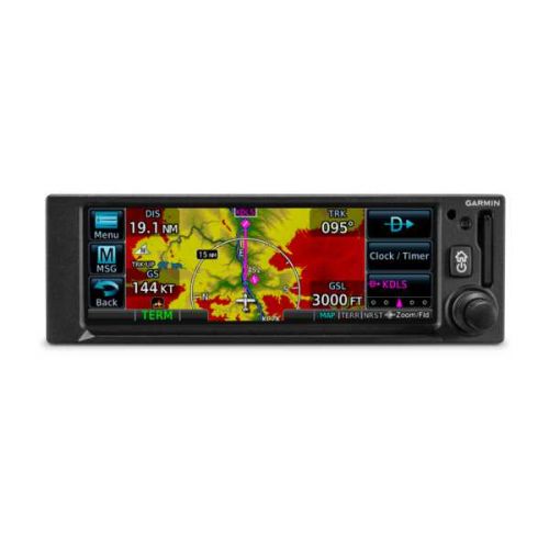
Se abbinato a soluzioni Garmin ADS-B dual-link, come il nostro transponder GTX ™ 345 o il ricetrasmettitore di accesso universale GDL® 88, il GPS 175 può visualizzare il traffico, così come i dati meteo senza abbonamento negli Usa, oppure puoi optare per il navigatore GNX ™ 375, che offre le stesse funzionalità del GPS 175, ma include un transponder per ADS-B "Out" e "In". Il link meteo ADS-B fornisce l'accesso in volo alle animazioni Immagini NEXRAD, METAR, TAF, venti e temperature in alto, PIREP, NOTAM e altro ancora.
Se dotato di una soluzione ADS-B compatibile, gli avvisi visivi aiutano a riconoscere ed evitare potenziali conflitti nello spazio aereo occupato e all'inizio o alla fine di ogni volo, la tecnologia TerminalTraffic ™fornisce l'immagine di velivoli e veicoli terrestri dotati di ADS-B nell'ambiente aeroportuale. I velivoli equipaggiati ADS-B durante il volo si distinguono facilmente dai veicoli terrestri e dagli aerei, che vengono visualizzati utilizzando colori e simboli distinti. Tutte le informazioni sono presentate su un diagramma SafeTaxi semplice e di facile comprensione con riferimento a piste, vie di rullaggio, posizioni di hangar e altro ancora.
Cockpit Integration
Il navigatore GPS 175 si interfaccia con una varietà di display di volo Garmin, tra cui G3X Touch (sperimentale e certificato), G5 (sperimentale e certificato), G500 / G600, G500 TXi / G600 TXi e alcuni display di terze parti selezionati. Inoltre, è compatibile anche con molti CDI per un'installazione più economica.
Inoltre, per una comodità ancora maggiore in termini di risparmio di lavoro, è possibile utilizzare la tecnologia Connext integrata per trasmettere informazioni tra GPS 175 e dispositivi portatili Garmin compatibili e dispositivi mobili con le app Garmin Pilot o FltPlan Go. Si possono anche creare piani di volo a casa e caricarli in aeroporto e trasmettere i dati GPS e le altre informazioni al tuo dispositivo mobile o portatile Garmin. Ancora, è anche possibile condividere il traffico ADS-B e le informazioni meteorologiche.
Caratteristiche
TSO applicability: C146e Class 3; C157b Category 1; C165a; C195b Category B1, B3, B5, B7
Dimensioni Display: 4.8" (122.5 mm) diagonal
Risoluzione Display: 732 pixels (W) x 240 pixels (H)
Unit bezel height: 2.02" (51.0 mm)
Unit bezel width: 6.25" (159.0 mm)
Unit depth with connectors: 6.58" (167 mm)
Peso (solo unità): 1.3 lbs (0.6 kg)
Maximum altitude: 35,000 ft
Input voltage range: 9 VDC - 33 VDC
Maximum display brightness: 260 fL
Operating temperature range: da -20° C a 55° C
Versione Bluetooth: 4.2
Numero di canali GPS: 15 (12 GPS e 3 GPS/WAAS/SBAS)
LAT/LON position accuracy: <1.25 meter RMS horizontal, < 2 meter vertical, with WAAS
Maximum velocity: 1,000 knots (above 60,000 feet)
Position update Interval: 0.2 sec (5 Hz)
****************************************************************************************************
Gps Garmin 175 w/ GA 35 antenna
Gps 175, PN: 010-01822-60
GA 35, PN: 013-00235-00
International Datacard
LPV Approaches
Slim, all-in-one touchscreen GPS navigator for Part 23 Class I/II aircraft (weighing less than 6,000 lbs) and experimental/amateur-built aircraft
Take advantage of WAAS GPS navigation with LPV approaches, which offer minimums as low as 200’ to greatly expand your operational capability
Pairs with select Garmin flight displays, or integrates directly with your existing course deviation indicator (CDI) for cost-effective installation¹
Visualize your entire flight plan, including departures, arrivals, instrument approaches, holding patterns and more on a rich, dynamic global moving map
Wirelessly transfer flight plans and stream weather, traffic, GPS position and backup attitude via built-in Connext® technology to the Garmin Pilot™ app and more
Big capabilities come in a small package with the GPS 175 navigator. With its bright, clear high-resolution touchscreen display, you can have the advanced navigation functions you’ve always dreamed of. Entering flight information is a cinch, and accessing every function is fast and easy. It’s equally at home in certificated aircraft or an experimental aircraft. And it’s the same 2” height as older navigation equipment and can allow you to keep the legacy composite CDI already in your aircraft to minimize installation cost¹. That makes GPS 175 the smart, affordable way to add next-generation navigation to your favorite airplane.
Perfect Touch
The moment you power up GPS 175, you’ll see a familiar Garmin homepage on the 4.8” display, which puts the most important functions within only a few touches. Navigate to dedicated pages for the moving map, terrain, nearest airports, flight plan, procedures, waypoint information, utilities and more. With shortcuts available to the flight plan and Direct-to functions on almost every page, navigation features are usually just a tap away. Use your finger to pan and zoom on any map, traffic and terrain page. Enter waypoint data with the on-screen keyboard. And touch the home button to get you back to the main page at any time.
For added control stability in flight, a shelf across the lower edge of the display serves to steady your hand in smooth and turbulent flight conditions. And if you prefer traditional controls, the concentric knobs provide yet another way to control many of the GPS 175 navigator’s functions.
Intuitive Navigation
With GPS 175, building and modifying flight plans is simple. As you enter waypoints, our FastFind feature automatically begins searching for the nearest identifier as soon as you start typing, so — in most situations — a press or 2 reveals just what you were thinking. You can also create holds, insert Victor airways and corresponding exit options, and add departures, arrivals and instrument/visual approach procedures. Additionally, you can edit your route using the map screen; a handy "rubber band" feature lets you grab any leg of your flight plan route and move it to accommodate a deviation or ATC amendment to your flight plan.
A variety of dynamically drawn and displayed maps provide situational awareness and context to the flight plan by highlighting visual reporting points, navaids, SafeTaxi® diagrams and hazards such as obstacles, power lines and terrain. Plus, the Smart Airspace™ feature automatically highlights airspace close to your current altitude and de-emphasizes airspace away from the current altitude.
Advanced Approach to IFR
The SBAS/WAAS-certified GPS receiver can allow you to fly GPS-guided LPV glidepath instrument approaches down to as low as 200’, greatly expanding your operational capability. You can also access newer localizer performance (LP) and all area navigation (RNAV) approaches. Precise course deviation and roll steering outputs can be coupled to our GFC™ 500 and GFC 600 autopilots as well as select third-party autopilots so that IFR flight procedures such as holds, NextGen radius-to-fix (RF) legs and missed approaches may be flown automatically. In addition, the GPS 175 navigator lets you create and execute custom holding patterns over an existing waypoint or user-defined waypoint.
Plus, when operating in VFR conditions, GPS 175 can provide advisory vertical approach guidance based on a published glidepath angle or a 3-degree approach glideslope from the runway threshold, while considering terrain and obstacle clearance. With this advisory guidance, you’re able to fly more consistent, precise vertical glidepaths into a variety of airfields.
Add ADS-B Traffic and Weather
When paired with dual-link Garmin ADS-B solutions, such as our GTX™ 345 series transponder or GDL® 88 universal access transceiver, GPS 175 can display ADS-B traffic targets as well as subscription-free ADS-B weather data in the U.S. Or you can opt for the GNX™ 375 navigator, which offers the same capabilities as GPS 175, but includes a transponder for ADS-B “Out” and “In.” The ADS-B weather link provides in-flight access to animated NEXRAD imagery, METARs, TAFs, winds and temperatures aloft, PIREPs, NOTAMs and more.
When equipped with a compatible ADS-B solution, visual alerts help you recognize and avoid potential conflicts in busy airspace. Our patented TargetTrend™ relative motion technology offers a faster, more intuitive way to judge the direction and closure rate of intruding targets in relation to your aircraft’s position. For example, if traffic is ahead of you and traveling along the same track but at a slower rate, the motion vector would point opposite of its indicated direction of flight to show you are overtaking the traffic. And, at the start or end of each flight, TerminalTraffic™™ technology provides the most comprehensive picture of ADS-B equipped aircraft and ground vehicles in the airport environment. ADS-B equipped aircraft in-flight are easily distinguished from ground vehicles and taxiing aircraft, which are displayed using distinct colors and symbols. All information is presented on a simple, easy-to-understand SafeTaxi diagram with reference to runways, taxiways, hangar locations and more.
Cockpit Integration
The GPS 175 navigator interfaces with a variety of Garmin flight displays, including G3X Touch (experimental and certified), G5 (experimental and certified), G500/G600, G500 TXi/G600 TXi as well as select third-party displays¹. Plus, it’s also compatible with many legacy, composite-input based CDIs — allowing you to keep your existing CDI and have an easier, more cost-effective installation¹.
And for even more work-saving convenience, you can use the built-in Connext technology to stream information between GPS 175 and compatible Garmin portables and mobile devices running the Garmin Pilot or FltPlan Go apps. You can create flight plans at home and upload them at the airport. And you can stream GPS data and backup attitude information (from the built-in AHRS) to your mobile device or Garmin portable, making them even more useful cockpit companions. Better still, you can also share ADS-B traffic and weather information if you’re equipped with a compatible ADS-B solution.
Plus, our optional Flight Stream 510 installs in the memory card slot of GPS 175 to enable our Database Concierge database transfer and management capabilities via our Connext gateway. At home, you can download selected databases onto your mobile device by using the Garmin Pilot app. Then, once you get to the airport, Flight Stream 510 will automatically establish a wireless connection to the Garmin Pilot app and upload the databases from your device to your GPS 175 in minutes.
Spec.
TSO applicability: C146e Class 3; C157b Category 1; C165a; C195b Category B1, B3, B5, B7
Display size: 4.8" (122.5 mm) diagonal
Display resolution: 732 pixels (W) x 240 pixels (H)
Unit bezel height: 2.02" (51.0 mm)
Unit bezel width: 6.25" (159.0 mm)
Unit depth with connectors: 6.58" (167 mm) (measured from face of aircraft panel to rear of connector backshells)
Unit weight: 1.3 lbs (0.6 kg)
Maximum altitude: 35,000 ft
Input voltage range: 9 VDC - 33 VDC
Maximum display brightness: 260 fL
Operating temperature range: -20° C to 55° C (-4° F to 131° F)
Bluetooth version: 4.2
Number of GPS channels: 15 (12 GPS and 3 GPS/WAAS/SBAS)
LAT/LON position accuracy: <1.25 meter RMS horizontal, < 2 meter vertical, with WAAS
Maximum velocity: 1,000 knots (above 60,000 feet)
Position update Interval: 0.2 sec (5 Hz)
